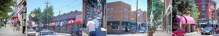
What are Neighborhood Business Districts?
Neighborhood Business Districts are the contiguous placement of businesses that are reliant upon neighborhood residents and also serve customers from other communities. Neighborhood Business Districts are located on primary streets in the neighborhood.
Typically, Neighborhood Business Districts are composed of retail stores, restaurants, personal services, and other similar walk-in customer oriented businesses. Neighborhood Business Districts help to define the unique character of their neighborhood and are critically important to the visual impact of the neighborhood and to the maintenance and revitalization of the neighborhood.
Why are Neighborhood Business Districts Important to the City?
Neighborhood Business Districts are a critical component of neighborhood revitalization since they:
- Provide goods and services for neighborhood residents,
- Provide jobs for neighborhood residents,
- Occupy key intersections and very visible areas within neighborhoods, and
- Serve as an economic and tax generator for the neighborhoods and the City.
The maintenance and revitalization of a healthy network of Neighborhood Business Districts is as important to the City of Cincinnati as is the maintenance and revitalization of the Downtown area and the maintenance and revitalization of the City's housing stock.
Cincinnati's Business Districts
NBD areas recognized by community representatives are:
| Neighborhood | General Boundary |
|---|---|
| AVONDALE (A) | Reading Road from Lincoln & University Avenue to Blair Avenue (Avondale Town Center). |
| AVONDALE (B) | Burnet Avenue from Forest Avenue to Erkenbrecher Avenue, Vine Street from Forest and Woolpert to Ehrman, Rockdale west of Reading Road, Burnet Avenue south to Martin Luther King. |
| BOND HILL | Reading Road from Anita and Andina Street north to Dale Rd. and Elizabeth Place. |
| CAMP WASHINGTON | Colerain Avenue from Elam Street to Township Avenue, Hopple Street from I-75 to Garrard. |
| CARTHAGE | 70th Street north to Paddock Road on Vine Street. |
| CLIFTON | Ludlow Avenue from Whitfield Avenue to Brookline Avenue, Clifton Avenue from Terrace Avenue to Hosea Avenue. |
| CLIFTON HEIGHTS | McMillan Street from Ravine Street to Vine Street, Calhoun Street from Vine Street to Clifton Avenue. |
| COLLEGE HILL | Hamilton Avenue from 5742 Hamilton to Wittlou Street. |
| COLUMBIA TUSCULUM | Eastern Avenue from Stanley Avenue to Delta Avenue, Delta Avenue from Eastern Avenue to Golden Street, Columbia Parkway from Delta Avenue to Stanley Avenue, Stanley Avenue from Columbia Parkway to Eastern Avenue. |
| CORRYVILLE | Vine Street from Rochelle Avenue to Wm. Howard Taft Road, University Avenue from Euclid Avenue to Jefferson Avenue. |
| EAST PRICE HILL | Glenway Avenue from Hawthorne Avenue to Beech Avenue. |
| EAST WALNUT HILLS | Woodburn Avenue from Locust Street to Lincoln Avenue, Madison Road from Victory Parkway to Hackberry Street. |
| EVANSTON | Montgomery Road from Hewitt Avenue to Jonathan Avenue, Woodburn Avenue from Ruth Avenue to Fairfax Avenue. |
| HARTWELL | Galbraith Road north on Vine Street to Hillsdale Avenue. |
| HYDE PARK(A) | Erie Avenue from Michigan Avenue to Zumstein Avenue, Edwards Road from Observatory Road to Erie Avenue. |
| HYDE PARKEAST (B) | Erie Avenue from Victoria Lane to Pinehurst Avenue |
| KENNEDY HEIGHTS | Montgomery Road from Tyne Avenue to Coleridge Avenue. |
| LOWER PRICE HILL | State Avenue from Hopkins Avenue to St. Michael Street, W. Eighth Street from Glenway Avenue to Depot Street. |
| MADISONVILLE | Intersection of Madison Road and Whetsel Avenue. |
| MT. ADAMS | St. Gregory Street from Hatch Street to Jerome Street, Pavilion Street from Belvedere Street to St. Gregory Street. |
| MT. AIRY | Colerain Avenue from Kirby Road to slightly south of North Bend Road (5434 Colerain Avenue). |
| MT. LOOKOUT | Intersection of Delta Avenue and Linwood Avenue |
| MT. WASHINGTON | Beechmont Avenue from Crestview Avenue to Mears Avenue. |
| NORTH AVONDALE | Glenwood Avenue (south) to Asmann (north), Reading Road from Asmann. |
| NORTHSIDE | Hamilton Avenue from Hobart Place to Knowlton's Corner (Intersection of Hoffner Street and Spring Grove). |
| OAKLEY | Madison Road from Drake Avenue to Brazee Street. |
| O'BRYONVILLE | Madison Road from Elmhurst Avenue to Lavinia Street, Torrence Parkway from Elmhurst Avenue to Madison Road. |
| OVER-THE-RHINE (A-Main St.) | From Central Parkway in south to Liberty Street in north including across 13th Street to Sycamore down Sycamore to Reading and back to Main Street. |
| OVER-THE-RHINE (B-Vine St.) | From Central Parkway in south to McMicken/Findlay five points intersection. |
| PLEASANT RIDGE | Montgomery Road from Lester Road to Woodmont Avenue, Ridge Road from Parkview Avenue to Woodsfield Street. |
| ROSELAWN | Reading Road from Section Road north to Summit Road, Brookcrest to Reading Road and Shanandoah (includes Valley Shopping Center). |
| SAYLER PARK | Gracely Drive from 100 feet south of Twain Avenue to Thelma Avenue. |
| WALNUT HILLS | E. McMillan Street from Ashland Avenue to Boone Street, Gilbert Avenue from Yale Avenue to Florence Avenue, Wm. Howard Taft Road from Ashland Avenue to Melrose Avenue, Victory Parkway from Cypress Street to Wm. Howard Taft Road. |
| WEST END | Linn Street from West Court Street north to York Street. |
| WEST PRICE HILL | Glenway Avenue from Seton Avenue to Boudinot Avenue. |
| WESTWOOD | Harrison Avenue from Kling Avenue to Higbee Street. |